Area dedicata ai simulatori di volo
-
Phant
- Capitano

- Messaggi: 14321
- Iscritto il: 19 settembre 2003, 15:14
- Località: Olbia
-
Contatta:
Messaggio
da Phant » 24 dicembre 2019, 19:40
Digitalcombatsimulator.com ha scritto:
DCS 2.5.5.41371 Stable
Added initial release of DCS Voice Chat.
Introduced new high quality A-10C cockpit.
Update for Normandy map (see details below).
Support of F-86F Hunters over the Yalu Campaign by Reflected Simulations.
- DCS World
ChinaAssetPack: Add all JF-17 related weapons
Fixed DCS crash in AI Follow task
Fixed GUI Error when use Trigger Zone window after change locale
Server folders navigation will work in case of user name in windows contains dash symbol '-' (2D hex)
Graphic options. Graphic preset "High" will set "Default" value for "Terrain objects shadows"
ME. Custom coalition list isn't applied to new mission if it isn't saved - fixed
Shadows of some aircrafts will not disappear in some conditions
In relation of integrating the Voice Chat there was implemented new SOUND options
AI Wingmen will use radar by default without player permission
SPG Msta armour tweaked
Fixed crash caused by train destroying
MP. Fixed servers disappearing from the master list (error 28)
RTC crash when multiplayer track replayed - fixed
MP. Fix crash when client is entering a server with JDAM in flight
F-5E AI. Nose gear strut will now fully de-hike before it enters the wheel well
Voice Chat button will be disabled in simulation
Fixed crash when ship is deactivated if helicopter starts up at this time
Ground vehicles. Adjusted armor for BRDM-2, COBRA, Fuchs, LAV-25, M113, GAZ TIGR
China Asset Pack: added ZTZ-96B
No active AI reaction for broken lock with fox 3 - fixed
Voice chat. Client in the default configuration can connect to a non-standard server port
Voice chat. Problem when server with UPnP can not see other clients in voice chat is fixed
Voice chat. Connect to local Voice chat server via localhost, not the external IP
Voice chat panel. Added Illumination of the PTT button while transmitting
MP. Check for second instance BEFORE creating the logs
Fixed helicopters slide off the deck of moving ships
AI Spitfire erratic behaviour fixed
AI UH-1 gunner. Attack enemy helicopters restored
Dedicated server. Added the ability to take a screenshot of any player's DCS window
Corrected flight dynamics of AIM-120 missiles based on our latest CFD research. All changes increased the launch range by about 10-20%
AIM-120C got next changes:
- - Significantly reduced subsonic and transonic zero-lift drag
- Slightly increased of siupersonic zero-lift drag
- Reduced lift-induced drag
- Increased lift
AIM-120B got next changes:
- - Reduced lift-induced drag
- Increased lift
Both missiles received an updated calculation of thrust altitude dependency. Because of this, the thrust at altitude has become somewhat less, and the maximum speed is less
AI F-16C. Corrected landing gear compression on the ground
- DCS Normandy 1944 map
Textures massive update for fields, cities and towns, villages, airfields
Added four new regions in France that includes:
- - Cana district
- Quarantine estuary
- Coasts north of the Utah landing zone
- The Mont Saint-Michel area
Included six new airfields (The total number of airfields has been increased to 38 ):
- - Argentan is a single-lane track
- Barville is a two-lane dirt track
- Essay is a single-lane grass track
- Goulet is a single-lane grass track
- Hauterive is a single-lane grass track
- Vrigny is a single-lane grass track
- Conches is a single-lane concrete track
Airfields have a significant increase in detail with many more objects.
Trees and forests have been updated to use SpeedTree, with 20 unique types of trees.
More detailed Atlantic Wall:
- - Added coastal anti-tank hedgehogs, barbed wire, etc.
- 8 zones were added that includes artillery batteries.
New, detailed scenery has been added that includes:
- - Le Mont-Saint-Michel
- Jumièges Abbey
- Cathedral of Notre-Dame de Rouen
- Rouen-Rive-Droite Station
- More detail was also added objects in the original map
The vector data was significantly improved over 20,000 sq kms.
Additional bug fixes and performance optimizations.
Bye
Phant

-
Phant
- Capitano
- Messaggi: 14321
- Iscritto il: 19 settembre 2003, 15:14
- Località: Olbia
-
Contatta:
Messaggio
da Phant » 1 gennaio 2020, 17:58
-
Phant
- Capitano
- Messaggi: 14321
- Iscritto il: 19 settembre 2003, 15:14
- Località: Olbia
-
Contatta:
Messaggio
da Phant » 3 gennaio 2020, 16:50
NineLine - Community Manager ha scritto:
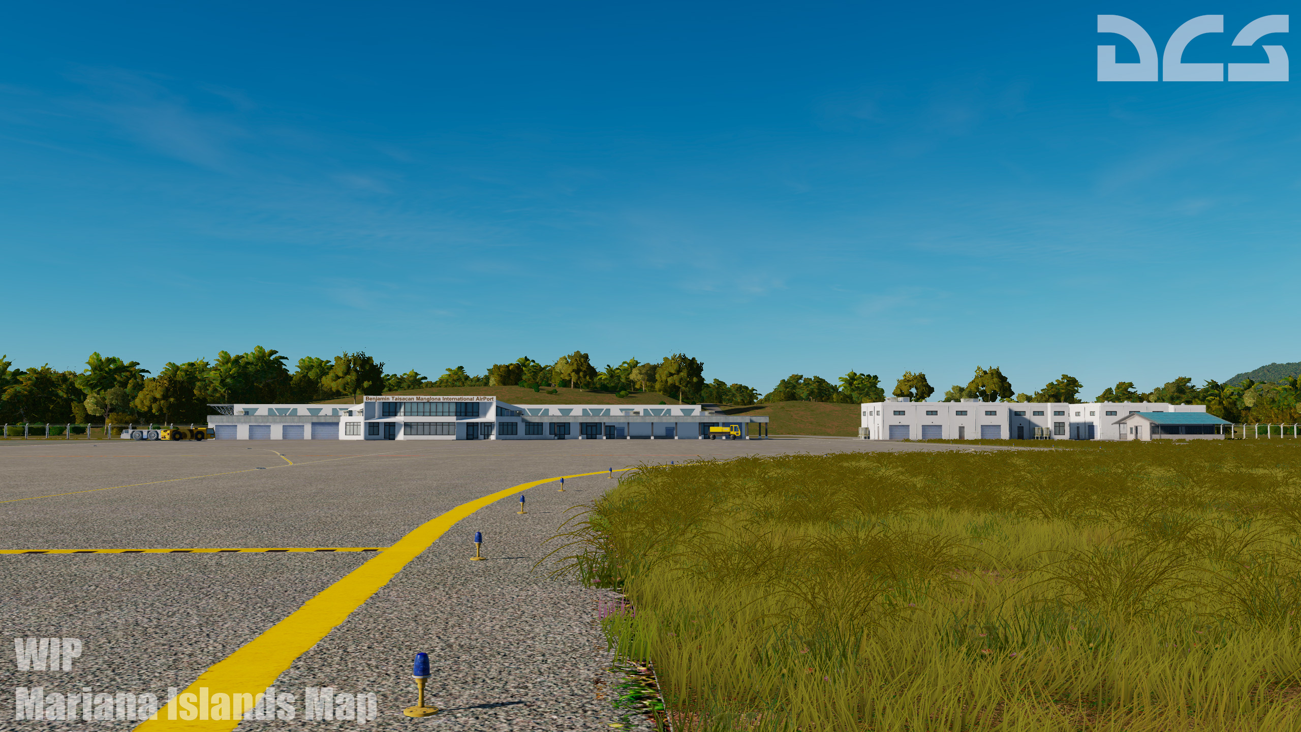
 Mariana Islands Map Announcement!

Since the release of DCS World, the sole free map has been the Caucasus Map. Although a great map and the recipient of a huge update in DCS World 2.5, we are happy to announce a second, free map for DCS World! For this new map, we want to use our latest map technologies and provide a very different combat environment in a new part of the world. The map must have the following features:
- A very large ocean area with a few islands. Ideal for carrier operations.
- Islands that are situated such that airfields have natural red, blue, and contested locations.
- Home to at least one modern-day USAF base.
- Feasible for US, Russia, and China operations in the Pacific.
- Take advantage of the Chinese Assets Pack.
Taken as a whole, there is only one natural choice: the Mariana Islands. It will initially be a 400 x 400 km map with the option to expand further in the future. Home to one of the largest USAF air bases in the region, Andersen AFB on Guam serves as an anchor of US forces in the Pacific region, but it is within reach of both Chinese and Russian Pacific forces to the north. The same island chain also served as the backdrop of the World War II battles of Guam, Saipan, and Rota, as well as the carrier vs. carrier Mariana Islands battle.

At release, the following islands will be included and modelled at an extreme level of accuracy using our latest map and graphics technologies:
Guam
- Andersen AFB.
- Weapons storage bunkers northwest of Andersen AFB.
- Ordnance Annex in south-central next to Santa Rita.
- Antenna array installation on the west coast.
- Antonio B. Won Pat International Airport.
- Abandoned Northwest Airfield in the northeast corner of the island.
- Abandoned Orote Airfield at Crote Pointe.
- US Naval station and Guam Port Authority at Apra Habor / Sumay.
- Fort Soledad and Fort Juan Muna.
- Urban areas of Talofofo, Yona, Tumon, Yigo, Maggilao, Asbeco, Dededo, Inarajan, Santa Rita, Agat, Piti, Asan, Hagatna, Barrigada, Magilao, and Adacao, Agana Heights, Asan-Maina, Chalan-Pago-Ordot, Mongmong-Toto-Maite, and Umatac.
- The University of Guam.
- Leo Palace Resort.
Saipan
- Saipan International Airport.
- Port of Puerto Rico.
- Urban centers of Kagman, San Roque, Tanapag, Garapan, San Vucente, Dandan, Chalan Kiya, Susupe, Chalan Kanoa, Afetna, and Chalan Kiya.
- Golf courses at Agingan, Kagman, and along the eastern coast.
- Memorial at the east end.
Tinian
- Tinian International Airport.
- The abandoned airfield at the north end of the island.
- Urban areas of San Jose / harbor and Marpo Heights.
- Antenna array along the central west coast of the island.
Rota
- Rota International Airport.
- Urban areas of Sinapalu, Songsong, and Teneto Village.
- Golf course on the northern coast of the island.
- Abandoned weapon storage area on the east end of the island.
Aguijan

We are very excited to bring this new, free map to you in 2020 that will offer new gameplay, home to new units, and a new chapter for DCS World.


Bye
Phant
-
Phant
- Capitano
- Messaggi: 14321
- Iscritto il: 19 settembre 2003, 15:14
- Località: Olbia
-
Contatta:
Messaggio
da Phant » 6 gennaio 2020, 0:41
-
Phant
- Capitano
- Messaggi: 14321
- Iscritto il: 19 settembre 2003, 15:14
- Località: Olbia
-
Contatta:
Messaggio
da Phant » 10 gennaio 2020, 3:12
-
Phant
- Capitano
- Messaggi: 14321
- Iscritto il: 19 settembre 2003, 15:14
- Località: Olbia
-
Contatta:
Messaggio
da Phant » 10 gennaio 2020, 16:44
NineLine - Community Manager ha scritto:
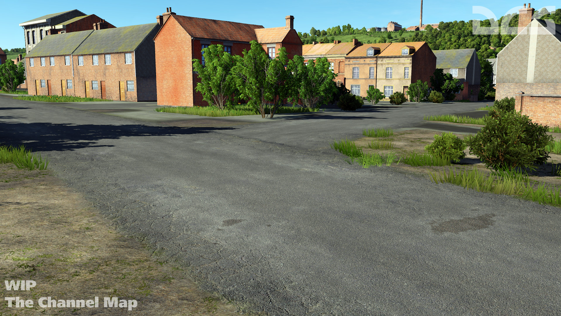
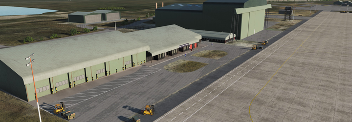
 The Channel Map
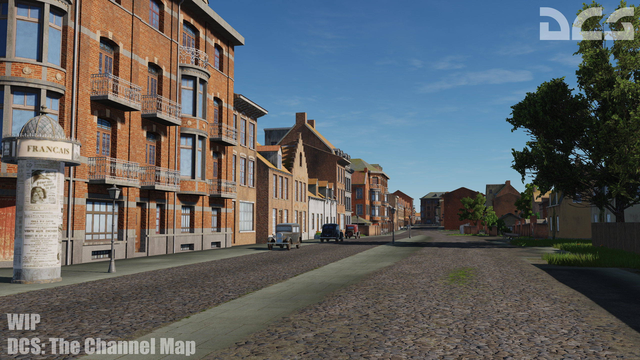
In addition to the Mariana Islands map, we are pleased to announce the first dedicated World War II map for DCS World that is created by Eagle Dynamics: The Channel map! This map will represent southeast England, the English Channel, and portions of the low countries and north eastern France. The map is built to support missions and campaigns between the late 1930s and 1945 with a new level of detail and realism not seen before in a DCS World map. Airfields of the map include:
- Manston
- Detling
- Hawkinge
- Lympne
- Dunkirk Mardyck
- Saint-Omer Longuenesse
- Merville Calonne
- Abbeville Drucat

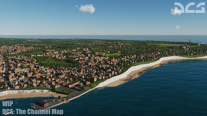
It will also include detailed renditions of the cities, towns, road and rail network, forests, rivers, canals, communication lines, radar stations, of this important region during the Second World War.


DCS: The Channel Map will be available for pre-order with a 30% discount in early February 2020.
Falkland Islands Map
The RAZBAM map team is making great progress on their Falkland Islands map, while at the same time creating new assets and player-units to suit.
Syria Map
After completing a great update to their DCS: Normandy 1944 map, Ugra Media will continue their work on the ambitious Syria map. This map spans from Turkey in the north to Israel in the south, with Syria and Lebanon in between. After an initial map review, the Ugra Team will be implementing the feedback to move forward on an early access release.
Bye
Phant
-
Phant
- Capitano
- Messaggi: 14321
- Iscritto il: 19 settembre 2003, 15:14
- Località: Olbia
-
Contatta:
Messaggio
da Phant » 22 gennaio 2020, 1:02
Facebook.com/RazbamSim ha scritto:
Modelviewer pic of the Canberra B2 from Argentina's air force, we are aware of some mistakes in the livery (mostly regarding stencils) but as many stuff regarding this, is WiP, in-game pics will follow.


FONTE https://www.facebook.com/RazbamSims/pos ... &__tn__=-R
Bye
Phant
-
Phant
- Capitano
- Messaggi: 14321
- Iscritto il: 19 settembre 2003, 15:14
- Località: Olbia
-
Contatta:
Messaggio
da Phant » 24 gennaio 2020, 18:22
NineLine - Community Manager ha scritto:
 Win the Channel Map!
For those of you that enjoy painting skins for your favourite aircraft, this contest is for you! Using the official template found here, we are holding a paint the Anton contest. We will choose the top 10 (or so) best submissions. If your submission is chosen, you will have your name added to the DCS: Fw 190 A-8 Anton credits, and your work will be included with the Fw 190 A-8. You will also receive one free copy of the upcoming DCS: Channel Map (no substitutions).
Here are some of the requirements and details:
- The skin must be created using this template.
- The skin can be historically accurate or fictional. However, the skin must be associated with one of the countries currently present in DCS World.
- Please do not use nazi swastika.
Here are instructions for saving textures with MIP levels using NVIDIA Texture Tools for Adobe Photoshop.
Please upload completed skins to the dedicated topic in the forum.
The contest will run until February 16th, 2020.
Best of luck to all contestants!
Bye
Phant
-
Phant
- Capitano
- Messaggi: 14321
- Iscritto il: 19 settembre 2003, 15:14
- Località: Olbia
-
Contatta:
Messaggio
da Phant » 29 gennaio 2020, 3:02
-
Phant
- Capitano
- Messaggi: 14321
- Iscritto il: 19 settembre 2003, 15:14
- Località: Olbia
-
Contatta:
Messaggio
da Phant » 31 gennaio 2020, 17:18
-
Phant
- Capitano
- Messaggi: 14321
- Iscritto il: 19 settembre 2003, 15:14
- Località: Olbia
-
Contatta:
Messaggio
da Phant » 8 febbraio 2020, 18:01
-
Phant
- Capitano
- Messaggi: 14321
- Iscritto il: 19 settembre 2003, 15:14
- Località: Olbia
-
Contatta:
Messaggio
da Phant » 18 febbraio 2020, 2:21
-
Phant
- Capitano
- Messaggi: 14321
- Iscritto il: 19 settembre 2003, 15:14
- Località: Olbia
-
Contatta:
Messaggio
da Phant » 12 marzo 2020, 1:37
-
Phant
- Capitano
- Messaggi: 14321
- Iscritto il: 19 settembre 2003, 15:14
- Località: Olbia
-
Contatta:
Messaggio
da Phant » 13 marzo 2020, 19:53
-
Phant
- Capitano
- Messaggi: 14321
- Iscritto il: 19 settembre 2003, 15:14
- Località: Olbia
-
Contatta:
Messaggio
da Phant » 5 aprile 2020, 16:48
Bye
Phant
/Reparto_Affari_Generali.png)